Sample Landery analysis
9800 & 9750 5 Mile Road NE · Grattan Township, MI
Preliminary recommendation
Preliminary opportunity
Moderate confidenceProceed with focused due diligence. This public sample shows how Landery compares reuse, greenfield and access possibilities without treating a concept as an approval.
Ranked paths
Scenario comparison
1
Existing-site reusePreferred
2
Southern greenfield via KehoeStrong alternative
3
Northern-pocket conceptField-test option
4
Direct 5 Mile accessHigh conflict
Hidden-cost watchlist
Questions before commitment
- Local requirementsThis public sample presents an abbreviated view of a Landery analysis. Live analyses for supported jurisdictions include the applicable source-dated findings available to the system.
- Wetland field confirmationMapped edges do not establish jurisdictional limits.
- Septic suitabilitySSURGO screening cannot replace on-site evaluation.
- Legal accessTitle, road agency and township confirmation control.
Evidence map
Official data and conceptual possibilities stay visually distinct.
This sample tests a realistically sized home, septic reserve, well, yard and access concept against mapped evidence. Concepts are planning illustrations—not surveyed or approved locations.
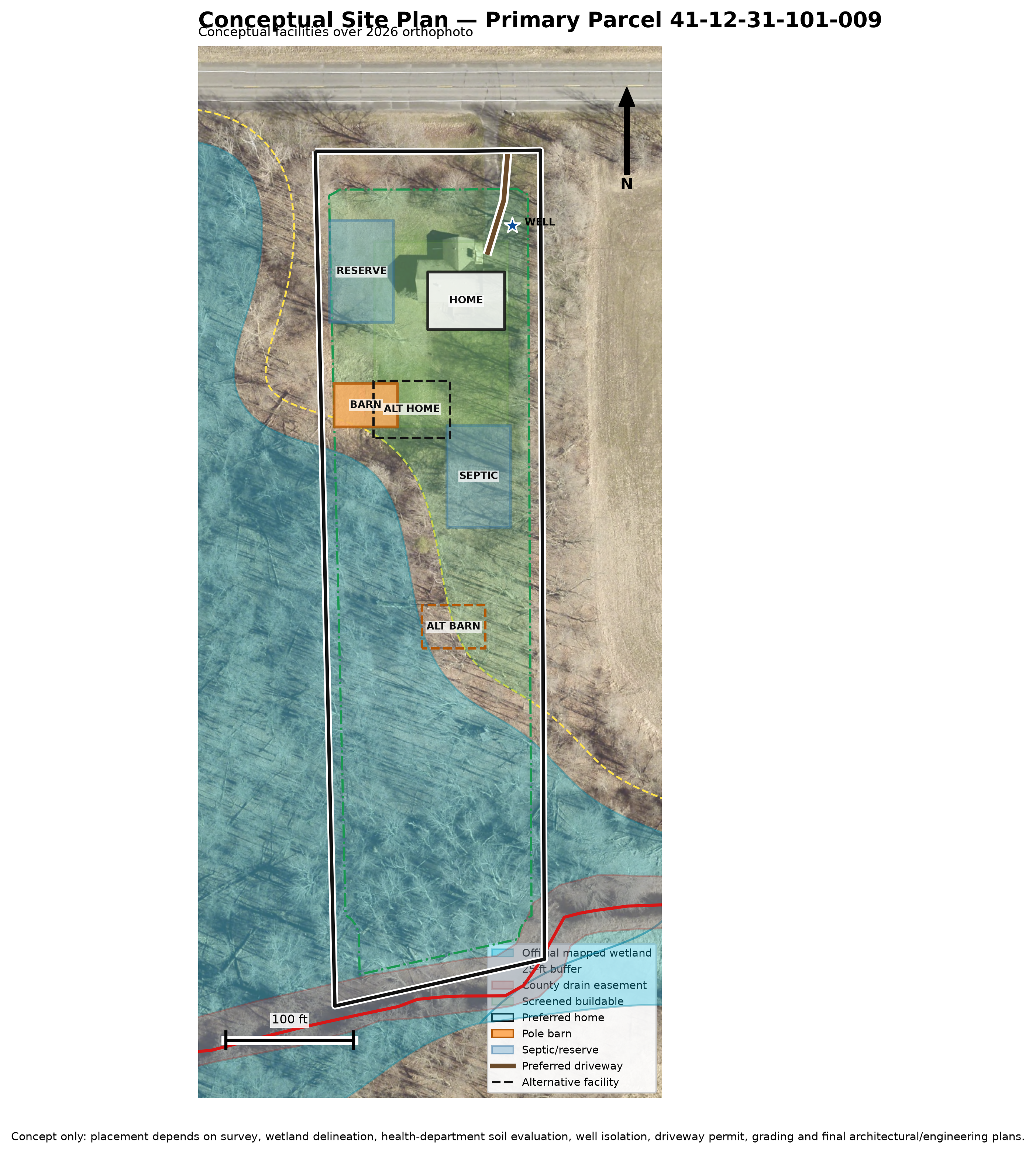
Property-specific evidence summary
The full package, visible in the public sample
Each finding states what the saved evidence supports, what it does not establish and which source or measurement produced it.
Parcel and jurisdiction
Two adjoining Grattan Township parcels are analyzed together as one 14.42-GIS-acre decision unit. The 14.98 assessor acres remain separately labeled.
Kent County parcel identity and geometry · retrieved July 28, 2026Local zoning requirements
The saved screen maps the parcels to A-2 Agricultural: 3-acre minimum area, 330-foot width/frontage, and 70-foot front, 20-foot side and 50-foot rear yards. Township confirmation still controls.
Grattan Township zoning map and ordinance · rules verified July 2026Wetlands and hydric soils
Combined EGLE/NWI mapped wetland evidence identifies 4.81 acres in the preliminary screen. Hydric soils remain a separate warning and field delineation is still required.
Michigan EGLE, USFWS NWI and hydric-soil screening · retrieved July 2026Flood hazard
The saved FEMA snapshot returned no mapped Special Flood Hazard Area feature within the decision unit. This is a screening result—not elevation certification or a permit finding.
FEMA National Flood Hazard Layer · saved retrieval July 2026Soils and septic
SSURGO map units 11B and 7 cross the property, and the saved hydric screen identifies Cohoctah soil in part of the assemblage. On-site evaluation and health-department approval remain decisive.
USDA NRCS SSURGO and Michigan hydric-soil evidence · retrieved July 2026Terrain and drainage
USGS 3DEP and county contour evidence show more than 10 feet of relief. Candidate access is compared by length, sampled grade and mapped-constraint crossings before ranking.
USGS 3DEP bare-earth elevation and Kent County contoursRequested components and measurements
The concept tests a 2,600-square-foot, two-story home represented by an approximately 45-by-58-foot footprint, a 30-by-40-foot accessory building, septic and reserve areas, well, quarter-acre yard and turnaround.
Saved development program and deterministic layout measurementsAccess findings
Existing-site reuse ranks first. The straight 923-foot 5 Mile Road concept overlaps mapped wetland evidence for about 649 feet, while the Kehoe concept depends on an unverified 66-foot easement and title review.
Measured route alternatives, mapped road context and saved scenario geometryProfessional next steps
Confirm the parcel survey and title, obtain septic evaluation, verify wetland boundaries, and review any new driveway or easement with the township and road agency before relying on a concept.
Landery due-diligence sequence · preliminary guidance onlyInvitation-only beta
Landery is testing with two invited Kent County real-estate professionals.
Each tester receives five automated property analyses for thirty days. Processing depends on source availability, property complexity and successful automated validation checks.